Third Ave El Route and Cross Streets in Manhattan
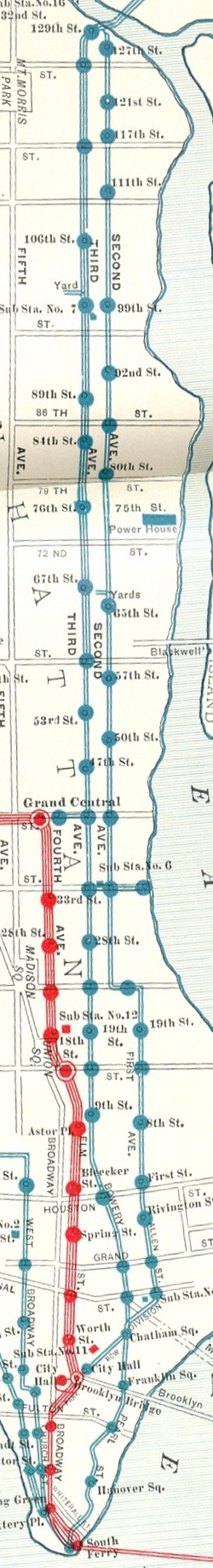
From the South Ferry Terminal in Battery Park Shared w/2nd Ave El
The 3rd Ave El structure turned right to cross
Whitehall St
Junction with the 9th Ave El ‘Y’ from the West
Front St crossing
Moore St
Broad St curve left or West onto
Coenties Slip ‘S’ crosses
Water St curve right to go North onto
Pearl St
William St on the left
Old Slip on the right
Hanover Sq Station is at
Hanover St
Beaver St ends at
Wall St
Pine St
Cedar St
Liberty St ends at
Maiden Lane
Fletcher St on the right,
Platt St on the left,
John St on the left,
Burling Slip on the right,
Fulton St Station,
Beekman St,
Ferry St on the left,
Peck Slip on the right.
Franklin Sq Station is at
Frankfort St to the left and
Dover St to the right.
Brooklyn Bridge overhead
Cherry St ends from the north, where
Pearl St becomes
New Bowery and crossed a box of streets diagonally bounded by
Oak St from the North,
Baxter St from the West,
New Chambers St crosses diagonally,
Chestnut St is in the middle of the box on the East
Madison St from the Northeast and
Roosevelt St crosses East/West
James St
Chatham Sq Station is located at the confluence of
New Bowery with
Oliver St from the East,
Park Row from the South, the junction of the
City Hall El Spur structure
East Broadway ends from the North and is aligned with
Park RowNorth from the
Chatham Sq Station the
2nd Ave El junction is at the end of
Division St on the East,
Doyer St on the West,
Begin Bowery Structure
Pell St on the West
Bayard St
Manhattan Bridge Plaza on the right
Canal St Station
Hester St
Grand St Station
Broome St
Kenmare St on the left
Delancey St on the Right
Spring St on the left
Rivington St on the right
Prince St on the left
Stanton St on the right
Houston St Station
First St begins the numbered streets on the right
Bleeker St on the left
Bond St on the left,
2nd St on the Right
Great Jones on the left,
3rd St on the Right
The Bowery ends at
4th St and is aligned with
Fourth Ave from the North
Third Ave Begins
5th, 6th and 7th Streets are on the right
8th St on the left,
St Mark’s Pl on the right
Stuyvesant St angles in from the Northeast and is aligned with
Astor Pl, which angles in from the Southwest to the
9th St (Hump Express) Station.
An inset of the 1904 IRT System Map
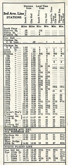
From 9th St North, all streets are numbered consecutively with stations at
14th
18th
23rd (Hump Express)
28th
34th
Junction with LIRR Ferry Spur N/B local track from East (until 1931)
42nd (Hump Express) and
S/B local track junction with
Grand Central Terminal Spur (until 1923)
47th
53rd
59th
67th
76th
84th
89th
98th Entry to the 99th St yard complex
99th - site of Substation #7 - coal and water facility in Steam Era
106th (Hump Express)
116th
125th (Hump Express)
129th Original Stub (single Island) Terminal (double decked 1916)
Junction East to 129th St Terminal Complex with
2nd Ave El
NYNH&H / NYW&B shuttle (until 1924)
Upper Level bypassed 129th St Complex to
Curve North for Junction with 2nd Ave El from the South
Harlem River Bridge (double decked 1917) to the Bronx
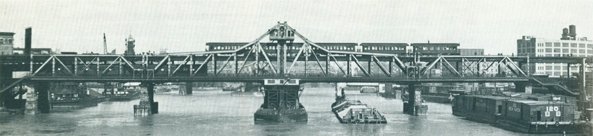
The Double Deck (1917) Harlem River Bridge to the Bronx